Nottingham East Midlands Airport (EMA)
City Orientation and Maps
(Nottingham, England)
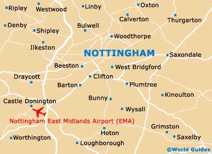
The city of Nottingham is located in the county of Nottinghamshire, in the east Midlands area. Nottingham lies close to many prominent cities and towns, such as Derby - just 26 km / 16 miles to the west, and Leicester - around 43 km / 27 miles to the south. Also nearby, Loughborough is 32 km / 20 miles south of the city and can be reached in around 30 minutes, being particularly close to Nottingham East Midlands Airport (EMA), which stands just a few miles to the north-west and serves flights to both European and domestic destinations.
Nottingham East Midlands Airport (EMA) Maps: Important City Districts
As with many large cities in England, Nottingham is divided into a number of districts and regions by the inner ring road, which encircles many of the main attractions, restaurants and bars The city's train station is situated on the southern side of the canal, while the two bus stations can be found next to the Victoria shopping centre to the north, and the Broadmarsh shopping centre to the south.
Nottingham's tourist information centre is situated along Smithy Row on Old Market Square. The historic castle lies nearby, in the heart of the city, and contains gardens, a museum and an art gallery, all of which are just minutes away from the Tales of Robin Hood attraction and the ancient 'Ye Olde Trip to Jerusalem' public house. On the outskirts of Nottingham, remnants of the area's famous forest still remain and are now part of the Sherwood Forest Country Park, complete with visitor centre.
England Map

Nottinghamshire Map

Nottingham Map